Natural space | The Lusatians | Niederlausitz | Upper Lusatia | Sorbs and Wends | Museumscape
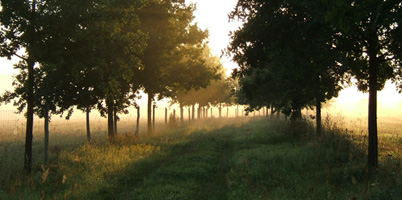
Natural space
In terms of landscape, Lusatia is divided into two different areas, Upper and Lower Lusatia, and they have a very different geological history.
The surface of Lower Lusatia, like that of the entire North German Lowlands, was shaped by the Ice Age during the Pleistocene period of the Earth's modern era, which lasted almost two million years. There were four ice ages with three interglacial periods. After melting, the ice left behind fertile ground moraines and hilly end moraines, large sandy areas and many lakes. The Lusatian Border Wall runs through Lower Lusatia, part of the southern land ridge that continues northwest into the Lower Fläming. It is the main end moraine of the Warthestadium of the Saale Ice Age. The highest elevation of the Lausitzer Grenzwall is 167 m. The Southern Land Ridge represents a watershed here. The rivers Dahme, Spree and Neiße coming from the south have created breakthroughs. To the south of the Lusatian border wall is the glacial valley of the Black Elster. The Baruth glacial valley belongs to the younger glacial series as a drainage channel, whose bed in Lower Lusatia is used by the Spree, which branches here to form the Spreewald. Almost unique in the world is the Muskauer Faltenbogen, an upsetting moraine of the Saale Ice Age. The inland ice glacier compressed the sand and lignite layers in front of and below it over a length of more than 40 km to form a horseshoe-shaped fold. It is preserved as a flat range of hills on both sides of the Neisse. The surface of Lower Lusatia was fundamentally created in the late Middle Pleistocene about 150,000 years ago and shaped in the following epochs of the Late Pleistocene and Holocene by glacial deformation (deformation by glacial ice), but above all by weathering, erosion, scouring and drifting as well as by sedimentation. Lower Lusatia is thus largely lowland, which was originally covered by extensive moors, swamp forests and beech-oak forests. In the 19th century, pine forests were widespread. In recent times, the Lusatian Lakeland has been created through the recultivation of the Lusatian lignite mining area.
Upper Lusatia, on the other hand, presents a completely different picture, geomorphologically it is characterised by the uniform Lusatian granite massif. It is home to the Lusatian Mountains and the Zittau Mountains (highest elevation: Lausche, 793 m above sea level), both of which belong to the German low mountain ranges. These developed from the great Variscan Mountains of the Palaeozoic era, which extended in a great arc from the French Central Plateau to the Moravian Gate. When the Alps were unfolded in the Tertiary period (beginning 60 million years ago), this mountain range, which had already been heavily eroded, broke up into individual floes, abraded, rounded shapes. The middle open undulating hill country between Kamenz and Löbau, with Bautzen in the centre, the Oberlausitzer Gefilde, was well suited for agriculture and is still very productive today. The area was settled on a relevant scale for much longer than the neighbouring natural areas and was a main centre of Lusatian culture. Only the north and north-east of Upper Lusatia has been shaped by the ice age and is occupied by the flat Upper Lusatian heath and pond landscape. All the major rivers in Upper Lusatia flow from south to north. In the west, the Pulsnitz used to form the border to Saxony. The Spree starts in the very south of the state and flows through Bautzen. The Lusatian Neisse rises in the Bohemian Jizera Mountains, enters Upper Lusatian territory near Zittau, flows through Görlitz and leaves the state near Bad Muskau in the direction of Lower Lusatia.
The Lusatians
Lusatia is a region that can be divided into two parts geologically, but also politically and culturally. The name "Lusatia", which was used in the past, designates two different adjoining countries: Upper Lusatia and Lower Lusatia. The name Lusatia originally referred only to the area around Cottbus (the old land of the Lusitzi), today's Lower Lusatia, which was settled by West Slavic tribes. After the name expanded in the 15th century to include the areas around Bautzen, Görlitz and Zittau, today's Upper Lusatia, the distinction between Lower and Upper Lusatia became common.
Borders of Lower Lusatia
The area of Niederlausitz has historically fluid borders and it is problematic to draw clear lines. In the north, the border runs roughly along the course of the Spree River, roughly on the line Eisenhüttenstadt, Schwielochsee, Neu Lübbenau. To the southwest, the river valley of the Schwarze Elster, to the west the Niedere Fläming and to the northwest the Teltow form the border of Lower Lusatia. In the south, Lower Lusatia is bordered by the course of the Black Elster. Where it meets the Lower Lusatian heathland, we extend its course by an imaginary line to the east, which crosses the Neisse and leads to the Lower Silesian Heath (Bory Dolnośłąskie). This roughly gives us the southern border. In the east, the Bober (Bobr), where it enters the Oder, borders the region.
Borders of Upper Lusatia
Upper Lusatia is the region on both sides of the upper Spree between the Elbe and Neisse rivers. In the west, the Pulsnitz used to form the state border with Saxony. The eastern border of the old Upper Lusatia was marked by the Queis, which also flows past Lauban and flows into the Bober further north on Silesian territory. The Elbe Sandstone Mountains and the Lusatian Mountains follow to the south.
The history of both countries shows many parallels. However, due to the fact that both regions were separate constituent states and in part took considerably different developments, they should be considered separately.
Formation of the name Upper Lusatia
For the region between the rivers Pulsnitz in the west and Queis in the east (the old land of the Milzeners), various names such as "the whole land of Budissin" or "the lands of Budissin and Görlitz" were in use until the 16th century, but there was no uniform landscape name. The founding of the League of Six Towns in 1346 now led to a new country name. The reason for this was that in addition to the royal cities of Bautzen, Görlitz, Lauban, Löbau and Kamenz, Zittau, which had been Bohemian until then, was also incorporated into the Confederation and thus into the Bautzen Margraviate, for which the name "Land of the Six Cities" or "Six Cities" for short (Latin: "Hexapolis" or "terra hexapolitana") also became established.
From the 15th century onwards, the name "Lusatia" was increasingly used for the area of today's Upper Lusatia and finally for the whole of Lusatia (for the first time in 1409 at the University of Leipzig). In the following decades, the subdivision of Lusatia and the designation of the "six-city region" as "Lusatia superior", i.e. Upper Lusatia, became established (officially for the first time in 1474 in a document of the Hungarian court). It was not until the middle of the following century that the inhabitants themselves gradually used the name in the sense of their own regional identity.
Niederlausitz
Settlement
Early archaeological finds in Lower Lusatia gave their name to a cultural group living in eastern Central Europe since about 1200 BC, the Lusatian culture. It is a subgroup of the Urnfield cultures and was spread over a large area between eastern Germany, Poland and Hungary during the Middle and Late Bronze Age. In the period before the migration of peoples, Germanic tribes migrated into Lusatia, who in turn assimilated the Celts who had settled there. They largely migrated to the south and west. The territory of historic Lower Lusatia was settled by Slavic tribes (originally from the Warthe-Weichsel region or the areas north of the Carpathians) as a result of the great migration of peoples from the first half of the 6th century AD. Previously settling Germanic tribes had left or were absorbed into the Slavic ethnic group as a Germanic "residual population". The first written evidence of this period comes from a Frankish chronicler named Fredegar, who in 631 reported on the tribal association of the "Surbi", who gave their name to today's Sorbs. The tribe of the "Lusizi" ("Lunsizi", "Lusici") settled in the centre of Lower Lusatia. It is they who will give the name to the later Margraviate. Beyond, in the east, another large Slavic people, the Selpoli, settled in the area of Guben, along the Oder and Neisse rivers, in a southerly direction into the Lower Lusatian Heath, reaching the Lower Spree Forest in the west and the Lieberos Heights in the north.
The rural settlement, the village, was the main form of settlement in Lower Lusatia. The families of that time lived in irregularly laid out farmsteads of ground-level log buildings. In the 7th century, the castle ramparts, originally places of refuge for the tribal population and cattle in the event of enemy attacks, became a characteristic feature of Sorbian settlement. With the decline of the gentile society, their character changed. The extended family based on kinship relations was replaced by the village community with the village elder. Several villages formed a castle district (sorb. župa), with a castle as the centre and the lord of the castle (župan) and his warriors. A tribe consisted of several castle districts. At the head of the tribe was the prince. On the one hand, this social differentiation led to the development of the feudal nobility; the majority of the population consisted of free peasants, craftsmen and traders as well as unfree tribesmen (the forerunners of the later class of serf peasants).
Occupation and territorial consolidation
The expansion efforts of the neighbouring Frankish Empire began as early as the end of the 8th century and reached their climax with the consolidation of the East Frankish-German Empire (919). The goal was the permanent subjugation of the Slavic tribes for tribute payments. (Subjugation of the "Lusizers" in 932 by Henry I.) Despite fierce resistance from the Sorbian tribes, they were no match for the power of the already centralised German Empire. The conquest of the Slavic territories was accompanied by their Christianisation. In the 12th century, the administrative unit of Mark Lausitz was formed, administered as a royal fief by the Wettin margrave.
In the 11th and 12th centuries, larger landed estates emerged from the land divided up among margraves, knights, bishops and monasteries, together with villages and families. This led to a change in the form of dependency of the peasant population, who were now forced to pay differentiated taxes and render different services.
Further medieval land development in Lower Lusatia in the 12th and 13th centuries was essentially carried out with Sorbian farmers and isolated German settlers; only German foundations were rarer. The land was divided up by a locator (a nobleman, burgher or large farmer appointed by the lord of the manor or landowner) according to hoofs and given to the settlers; initially on favourable terms for the colonists. This situation then changed in the 16th century, when the nobility moved to expand their estates and impose ever greater burdens on the peasants. Lower Lusatia is thus a land conquered by the Germans, in which the old inhabitants largely remained sedentary and were only displaced to a small extent by German colonists.
Even into the 12th century, the Polish kings also claimed the area for their empire and were able to dominate the eastern part of the land for a time. In the 13th and 14th centuries, Lusatia was disputed between the noble dynasties of the Wettins of Meissen and the Ascanians of the Wittenberg and Brandenburg line.
With the 14th century, Lusatia became part of the Bohemian crown, of which the margraviate remained a tributary until 1635. In the 15th century in particular, but also in the 16th century, significant parts of Lusatia were lost to the neighbouring electorates of Saxony and Brandenburg through sale and pledge, for example the central Cottbus district in 1454. The Lusatian Diet also came into being at that time. The assembly of estates, divided into four curiae, was the most important political force in the land. In addition, a bailiff looked after the interests of the Bohemian king.
Between 1520 and 1540, the Reformation spread throughout the country. Lower Lusatia was the only region in the Bohemian-Habsburg sphere of power in which the Protestant estates gained church sovereignty, and that throughout the country. With the exception of Neuzelle Monastery, all other monasteries were dissolved.
In the course of the Thirty Years' War (Peace of Prague 1635), the Saxon Elector was enfeoffed with the Margraviate of Lower Lusatia, which remained territorially independent, with the Elector of Saxony also being the Margrave of Lower Lusatia.
Rural tenure
From the beginning of the 16th century, the nobility experienced a severe economic crisis due, among other things, to the declining purchasing power of money. The noble landowners saw a way out in the expansion of production combined with the enlargement of their own economy and the expansion of peasant services. The intensified social pressure on the Sorbian and German peasantry culminated, as is well known, in the peasant revolts, which also occurred in Lower Lusatia, albeit with a delay. This process of transition from landlordship to greater manorial rule continued after the Thirty Years' War. Initially, the numerous desolate peasant farms were incorporated into the manorial estate, but eventually the manor economy was enlarged by expelling the peasants from their land or by transferring them to smaller plots of land. This was accompanied by the conversion of hereditary property into non-hereditary property, i.e. the introduction of hereditary servitude.
Since the type of property right had little to do with the size of the estate, there were also "lassite" estates of different sizes, according to which, however, the services to be rendered by the peasants were determined. The lassite estate consisted of house and farm, field, meadow, hut, tools and inventory. Despite certain deviations in the scientific literature, one can assume the following historical distinction: Ganz-Hufner (o. Hüfner) or farmers [owning a whole hoof], Klein-Hufner or small farmers [owning three quarters of a hoof], Halbhufner, gardeners, Kossäten and Büdner; each with a graduated allocation of field, meadow, garden, yard space, wagon, plough, seed grain, livestock. The ratio also specifies how much and which livestock may be kept in the economy.
In the 18th century, it became increasingly difficult to clearly distinguish between the categories of peasant landownership, hereditary landownership and feudal landownership, as the strong economic pressure led to a blurring of the distinctions in the frohnleistung. The relationship between the manor and the peasantry underwent a radical change only with the social and economic upheavals that began in Germany at the end of the 18th century on the way to capitalism. They found their political expression in the Prussian reforms, especially the Prussian agricultural reforms since 1807, even if they were implemented more hesitantly in Lower Lusatia: (Lower Lusatia fell to Prussia in 1814/15, after the fall of Napoleon I.), (Lower Lusatia fell to Prussia in 1814/15 after the fall of Napoleon I.) The old constitution of the estates was retained for the time being after incorporation; the introduction of taxes on trade, land, consumption and persons was suspended; the revised town code (1808) was not introduced in Lower Lusatia until 1832; hereditary servitude was abolished in January 1819 (Prussia 1810)!
In the course of the reforms, the peasants (first of all those who were "capable") were able to transfer their "arable land" together with their farm into private ownership by purchase and cession of land. For most peasants, this release from hereditary servitude came at a high price (up to a third of the land was ceded to the lord of the manor), especially as manual labour was retained for a long time. Small farmers without a team often became propertyless farm labourers, as the lord of the manor could buy their land for cheap money. They had to work on the estate or go into the emerging industry.
While agriculture generally boomed at that time, conditions in Lower Lusatia were not so favourable. The lower yields hardly brought any improvement here in the 19th century. Most of the buildings were single-storey and solid construction was slow to catch on. The proportion of preserved wooden buildings is therefore still relatively high.
The new Prussians
At the end of September 1813, the old Prussian district of Cottbus, which was one of the areas ceded in 1807 after Prussia's defeat by Napoleon's troops, was repossessed by Prussia. On 22 May 1815, following the decisions of the Congress of Vienna, which determined the political and territorial reorganisation of Europe, the remaining six district areas of Lower Lusatia, which had previously belonged to the Kingdom of Saxony, fell to Prussia and were incorporated into the administrative district of Frankfurt an der Oder of the newly founded province of Brandenburg; the Margraviate was dissolved. The autonomy rights of the estates were gradually abolished and Lübben lost its function as the capital of a region that had been autonomous for centuries.
Between 1812 and 1848, the population of Niederlausitz grew by 42 percent. Almost three quarters of the 27,166,35 inhabitants lived in the countryside in 1840. The areas that came to Prussia were inhabited not only by Germans, but also by the Slavic minority of the Sorbs. The redistribution of territory led to an administrative fragmentation of their settlement area. Whereas in 1807 95 percent of the Sorbian population still belonged to Saxony, after the redistribution 80 percent of them were subject to the Prussian state, and only 20 percent remained in Saxony. Thus all the efforts of the Sorbian intelligentsia for national self-realisation were doomed to failure. The proportion of the Sorbian population in the total population of the two Prussian provinces of Brandenburg and Silesia was only about six percent, in Saxon Upper Lusatia it continued to be a quarter. Under Prussian rule, the oppression of the Sorbs intensified; in particular, administrative measures were taken to push back the use of the Lower Sorbian language, which was more than tolerated by the Protestant Church.
Lower Lusatia as a Landscape Concept
Around 1816, the reorganisation of the territorial administration began. Seven administrative districts, Cottbus, Sorau (today Poland), Spremberg, Calau, Luckau, Lübben and Guben were introduced. The administrative division essentially remained in place until 1945.
The National Socialist rulers of the "Third Reich" liked a partly comprehensive renaming of the regions, which mainly followed party-political divisions. Old distinctions were watered down, historically completely unjustified, and thus gave rise to confusion of terms, this also applied to Niederlausitz.
After the Second World War instigated by the German Reich, the parts of the country east of the Neisse came under Polish administration as a result of the Potsdam Agreement. The border became final through the "2 + 4 Treaty" concluded with German reunification in 1990 and the Treaty between the Federal Republic of Germany and the Republic of Poland confirming the borders existing between them of 14 November 1990.
After the Second World War, Lower Lusatia first belonged to the state of Brandenburg again and finally to the GDR. In the course of the territorial reform of 1952, most of Lower Lusatia was merged into the district of Cottbus. At the same time, the district town of Cottbus established itself as the regional centre of the remaining historical Lower Lusatia. With the political changes and the re-establishment of the state of Brandenburg after 1990, Niederlausitz is now only used historically or as a landscape term. Finally, the formation of large districts in 1993 (e.g. Landkreis Dahme-Spreewald) led beyond the historical boundaries of the Lower Lusatian region.
Niederlausitz
Lower Sorbian: Dolna Łužyca,
Upper Sorbian: Delnja Łužica,
Polish: Dolne Łużyce,
Latin: Lusatia inferior
Coat of arms
It consists of a white panier with a red ox. It is similar to the coat of arms of the town of Luckau, which was the "capital" of Lower Lusatia in the Middle Ages.
Upper Lusatia
Settlement
According to research into prehistory and early history, the area of Upper Lusatia was apparently sparsely populated until the later Bronze Age (11th to 9th century BC). The carriers of the Lusatian culture eventually penetrated the region from the Neisse valley and from Bohemia, and with the end of this first major settlement phase, only a small residual population probably existed in the region for several hundred years. Until Slavic tribes migrated from the east in the 6th and 7th centuries. The Milzen tribe settled in the area between the present-day towns of Kamenz and Löbau. Their centre was a castle settlement on the site of today's Ortenburg in Bautzen.
Eastern expansion and territorial consolidation
From the 10th century onwards, however, the independence of the Slavic tribes was threatened by the expansionist pressure of the East Frankish-German Empire under King Henry I. In 939, King Otto I succeeded in defeating the Milzeners again, and around 990 Margrave Ekkehard I of Meissen was able to finally subjugate the Milzeners. Territorial possession and missionary work went hand in hand, and Upper Lusatia was now assigned to the bishopric of Meissen, which had been founded in 968. Between 1002 and 1031, Upper Lusatia, similar to Lower Lusatia, came under the influence of the strengthened Polish kingdom.
The German king granted the imperial fiefdom or margraviate of Upper Lusatia to various margraves, kings and emperors for several centuries for administrative purposes only. This meant that the respective rulers could not incorporate Upper Lusatia into their ancestral lands. Thus the Upper Lusatian nobility developed exclusively from feudatories who had immigrated from the regions west of the Elbe. The margraviate of Upper Lusatia thus also has its own constitutional history. With the 12th century, Upper Lusatia finally came under the authority of Bohemian ruling houses. In this period, apart from the older Bautzen, all the important towns of Upper Lusatia were founded and all the important ecclesiastical institutions of the land were established. Under the Bohemian kings, the expansion of the land also intensified and German farmers were brought into the country.
Politically significant was the appointment of land bailiffs as deputies of the sovereign under the Ascanians (a central German dynasty of princes, margraves of Brandenburg since 1157) in the 13th century. With this sovereign office in Upper Lusatia, the powers of the burgraves and land judges were united in one hand and even expanded. The division of Upper Lusatia into the lands of Bautzen (Land of Budissin) and Görlitz, the most prominent event (until 1329), by Margrave Otto IV of Brandenburg in 1268, also occurred during the reign of the Ascanians.
The League of Six Cities
Under the rule of Charles IV, German king and king of Bohemia since 1346 (he was crowned emperor in 1355), some Upper Lusatian towns developed into new political, economic and cultural centres of the region. On 21 August 1346, the five most important royal towns in Upper Lusatia - Bautzen, Görlitz, Löbau, Kamenz and Lauban - and Zittau, which was still Bohemian at the time, founded the Six Towns League. This was done with the approval of the Bohemian king, who supported the towns with numerous privileges, and served to fight knighthood and highway robbery in Upper Lusatia. The confederation had special legal powers and was the bearer of statehood on behalf of the sovereign. The sovereign only sent a bailiff as his representative to Upper Lusatia, who was traditionally appointed from the nobility of one of the Bohemian crown lands (before 1620, only once is there evidence of an Upper Lusatian as bailiff). The alliance ultimately emerged strengthened from the war against the Hussites. Thus, by the end of the 15th century, the political system of the Margraviate of Upper Lusatia had largely consolidated. In addition to the bailiff, there was also a bailiff in Bautzen and Görlitz, so these three officials formed the entire royal administration. The centre of power in the state was the Estates Diet.
Upper Lusatia
Upper Sorbian: Hornja Łužica,
Lower Sorbian: Górna Łužyca,
Latin: Lusatia superior
Sorbs or Wends ?
For visitors to Lusatia, but also for many locals, the different designations of the Slavic minority living here as Sorbs or Wends still raises questions. Are the names one and the same? Or do they refer to different ethnic groups? Historically, the two terms go back to different traditions in the naming of peoples in East-Central Europe:
Roman historians initially transferred the name of several ancient tribes in Europe, the Venetians (Latin: Veneti, Greek: Enetoi), who lived before the birth of Christ in Brittany, in the eastern Po Valley and in the northern area of the Adriatic coast (today's Veneto region in Upper Italy), to the entire non-Germanic population east of the Limes. Thus, around 100 AD, Pliny (Roman politician and writer) referred to the Venedi as a presumably Slavic people in the Oder-Weichsel region. The name Wenden or Winden, derived from this, was later used in German to refer to all Slavs who settled in the area of what later became Central and Eastern Germany and in the Alpine countries since the migration of peoples.
In 631 AD, the name Surbi was documented by the Frankish chronicler Fredegar. It originally referred to the Slavic tribes living between the Saale and Mulde rivers. In the following centuries, this name also spread to the descendants of the Milzener and Lusizer tribes on the upper and middle Spree. Thus, this term has inserted itself into the mother tongue self-designation of the descendants of these Slavic populations: in Lower Sorbian Serby, in Upper Sorbian Serbja, thus in German Sorben.
Despite the fact that the term "Wenden" was used by Germans at the latest during the National Socialist era in a predominantly pejorative way, Sorbian parts of the population have used this term for their own designation, but have never adopted it in their mother tongue. Thus it is that even today in the villages around Cottbus many local people (Sorbs) refer to themselves as Wends. Nevertheless, many found this term discriminatory, and so after the Second World War in the Soviet occupation zone or the later GDR, the name Sorbs was agreed upon. After the political change in 1990, at the 1st general meeting of the Domowina regional association Niederlausitz on 31 May 1991, the delegates of the state of Brandenburg decided on the German designation Sorbs/Wends. Thus, in German usage, the two terms are (once again) de facto synonymous with each other.
Sorbian belongs to the West Slavic languages. In addition to many regional modifications, it has two main dialects, from which two written languages developed in the middle of the 19th century as final independent languages: Upper Sorbian, spoken in the area around Bautzen, and Lower Sorbian in the Cottbus area. These emerged as a result of the Reformation, when written forms of Sorbian were created on the basis of various dialects. There is a closer linguistic relationship to Polish, Czech and Slovak. After 1945, both main Sorbian dialects were recognised as official and school languages. There are transitional dialects and dialect types between Upper and Lower Sorbian in an area roughly from Muskau to Senftenberg and from Hoyerswerda to Weißwasser, as a kind of "overlap" of both languages.